In 2005, I attempted the Tahoe Rim Trail, and pulled out early for a couple of varying reasons..primarily I did not take care of my feet. Not that it was a hard trail, I’d knocked the JMT out the year before in 13 days, and I was still in great backpacking shape (although not as good as I am now). We finished the Desolation to Brockway Summit portion of the trail, and over the years I’ve done segments from Luther Pass, and Spooner Summit, but mostly dis-contiguous segments. That said, it’s a new year (well first day of spring of a new year), and it is time to do some goal setting. 2016 saw the least number of trail miles I’d done since my mid 20s, and this is a good year to bounce back.. I’ve only got about 100 SOTA points, and I have neglected my backyard. This year the goal is simple and still allows for other opportunities for getting out: lots of day hikes, 3 day weekends, and overnights to finish the TRT, and retrace, or take liberties with side trails the parts I’ve already done to get more SOTA summits. I intend to activate EVERY SOTA summit in the TRT corridor (and also knock off all summits in Desolation wilderness. This does NOT get every summit related to the Tahoe basin, but it’s going to be a lot of fun miles, and hopefully a pile of points for myself and chasers! I am a huge embracer of Leave NO Trace ethics. Anytime you venture into the backcountry you are a visitor in someone else’s home. Wildlife and the like depend on you not trashing their home.. SO..if you pack it in, pack it out, do not burn it, do not toss it, do not let it drift away in the wind. Leave the backcountry exactly as you found it, or a saying popular in the 80’s “Take only pictures, leave only footprints”.
I will put up a spreadsheet of sections, mileages etc as I finish the planning, so do consider this post a work in progress. All but five of the peaks are 8 point summits. All five of those summits are in the W7N association (Nevada), one is a 10 pointer and the last four are 6 pointers. One thing to note is that quite a few of the summits do require some off trail, and questionable terrain (in one case a whole day trip of off trail paralleling the trail). This plan is based upon my skills, and any followup trip reports are in NO WAY a scouting report for you. You the individual reading this must assess your own skills. As a member of local SAR, I see a lot of examples where humans tend to overestimate their capabilities with a tad bit too much reliance upon technology. Know the 10 essentials, carry them, and be weather smart! If you have any interest, but no experience in this level of hiking then I suggest you start easy in and around your home hills as altitude is not the place to break in a new skill set. I am not responsible if you get lost, and will not be making any GPX files available. You will need to do your own planning and use your own ‘noggin based upon your skills with navigation, off trail walking, and general trail walking.
For this purpose the trail will be broken down into a few segments with Desolation Wilderness being the last segment I intend to address. Desolation is my favorite area to visit; I love granite. It is part of the carrot that will keep me going! There are 104 points inside the boundary of Desolation; to date I have done one SOTA attempt and activation in Desolation (Maggie’s Peak W6/NS-135). So 96 to go. I have also snagged a few other peaks on the southern end of the trail.
Echo to Luther: I’ve not hiked the segment from Echo Summit south, however I have completed the segment to Luther Pass via Carson Pass to Big Meadow day hike. This segment of the trail (the Southern most end of the trail) gives an opportunity at Little Round Top (W6/NS-087), This would be a very doable overnighter with rolling out on a Friday night to make Showers Lake area (8 miles), grab Little Round Top first thing, then move over to the Red Lake Peak (W6/NS-062) and Stevens Peak (W6/NS-375) spine. At this rate there is one other kinda far off side peak, and time of day matters. That is Waterhouse Peak (W6/NS-092). Waterhouse is a side trip, rejoin the TRT at Big Meadow via the Scotts Lake Trail. Again, this assumes you have hiked this segment of the TRT, if you have not, then Waterhouse is WAY off the rails, and I’m viewing it more as a bonus challenge!
Luther Pass to Kingsbury Grade: There are four SOTA summits (five if time permits) to be gained on this segment, but there is a LOT of hiking and elevation involved. I have hiked and biked the majority of this segment, and have been on all five peaks at various times, and have activated three of them. Since I am focussing on uniques I will be skipping those three, but will call them out. The focus peaks this summer are Feel Peak (W6/SN-034) and Monument Peak (W6/NS-061). For those with time and ambition, camp at somewhere near Freel or on Jobs Sister and side trip to Jobs Peak (W6/NS-047). I would not consider it for this challenge because it leaves the TRT corridor. This side trip is probably a half day effort if you camped up high but it is another 8 points. Start at Big Meadow where I left off from the previous section. The first SOTA summit you can get is an unnamed and off trail ascent that has about 30-60 minutes of climbing from the trail corridor Pt 9647( W6/NS-084). For future reference a summit named “Pt ####” is named for it’s height as it is not a named peak. I have already completed this summit so I’ll be pushing for Freel, and do plan on camping on top on Job’s Sister. A night DX activation could be fun :D, and I could self spot from up here if needed. This should be a long day backpack in, and yes I am well aware there are two other ways to sneak up Freel, but remember, the goal is stick to the TRT corridor (or very nearby) and complete as many miles as possible! The third summit on this segment is “Pt 9614” (W6/NS-086) Another Nameless summit..and to date, I’m still the only person who has bagged this (under my previous call sign). This write up from that trip is a good lesson on how to handle yourself around wildlife. The nice thing about this peak is it is a few hundred feet climb directly above the TRT. The fourth summit and possibly the hardest to attain is Monument Peak (W6/NS-061) in the Heavenly ski resort. This will require some off trail with a 1000 foot climb to reach the peak from the pass the trail rolls thru. If it is anything like the scramble for the previous peak, it’s very sandy, so 3 steps up, 2 steps down etc..
Kingsbury to Spooner: This is one section I’ve identified as a day hike section. There are two summits on this stretch, and it’s only 11 miles. The two summits are nothing like the side day trips I’ve mentioned so far. Start early at Daggett Pass/Kingsbury Grade and head North. About half way up is Genoa Peak (W7N-TR-007) snag some lunch and do your activation. Genoa is a short off trail climb, it also may have a road since there are antennas up there. Continuing north is Duane Bliss Peak (W7N-TR-014). After this, it’s mostly a descent to Spooner Summit. Once at Spooner if time permits grab Captain Pomin Rock (W7N-TR-027), it’s outside the TRT zone in my opinion, but it is right off the road. Trying to do it as part of the next trip adds a bit of an epic factor. (or skip it, it’s only 6 points)
Spooner to Mt Rose Hwy: is a twenty-two mile stretch that runs along the eastern crest of Lake Tahoe. This is one section I am going to do as a southbound, and not northbound for where the summits lie on the trail. There are five summits along this stretch, three of the summits are 8 pointers, and two are 6 pointers. From Mt Rose highway side trip up Slide Mountain (W7N/WC-004). Head back down to the road and hop the TRT southbound. The next summit along this stretch. Pt 9225 (W7N/WC-005).This is one section of trail that is normally dry, this year might be the exception, but it’s a nine mile stretch of trail that normally does not have water (that’s 3-5 hours of hiking depending on speed). The next peak to snag is probably going to be first thing in the morning and camp will be very near the north end of Marlette Lake. The best access for this peak looks to be from the south: Herlan Peak (W7N/WC-008). I am probably going to camp in this area as I see water nearby. Herlan Peak is the northern most point of three prominent peaks heading north of Marlette lake.
 So, the last two peaks create a bit of a conundrum and will require some massive backtracking up hill to re-attain the TRT. There are two peaks that are pretty much on either side of the trail, however the side trip for this is a large downhill. The peak on the right is Snow Valley Peak (W7N/TR-006), and is right off the Rim Trail. There is a four way junction just before the peak and here is a road that heads all the way to the top as it is an antenna peak. Take the down trail and goto the peak on the left which sits above Marlette Lake and is unnamed: Pt 8728 (W7N/TR-013) . Plan for 60-90 minutes of walking to get to the peak on the left, the TRT stays high on the ridge, so you will need to back track to finish the TRT proper. Plan for that to be a 3-5 hour ordeal. Once back on the TRT you still have two more hours of walking (downhill) to Spooner Summit. This is possibly the hardest slog section just because of the terrain and the water situation. This is one trip report I am looking forward to doing, and hope to have this section done before the Rose to Toads mountain bike race
Rose Highway to Brockway: I am not sure how to address this one. There are only three summits on this section, and they are all at the Rose Hwy side of the trek. First up is Tamarack Peak (W7N/WC-003). Second up is Mt Rose (W7N/WC-001) which is the only 10 pointer on the whole trek. Last up in the same zone is Mount Houghton (W7N-WC-002). I’ve thought about doing these three peaks as a single day hike (and you could probably snag Slide Mountain the same day too). That said, after knocking off the three head on towards the west. One other option is to leave Slide Mountain off the previous section, and go for four peaks in a single day.
Brockway to Tahoe City: Three eight point peaks. The first one is right off the trail, and only a mile in, Gold Star Peak W6/NS-189. Another four miles in are the other two peaks. Mt Pluto (W6/NS-138) which sits on Northstar ski resort. Still within the corridor and is a side trip, but mellow grades. After Pluto, head up to Mt Watson (W6/NS-147) which is right above Watson Lake. This can probably be done as a single day hike, or another opportunity to do a night activation on Watson and camp at Watson lake. It’s another 8-9 miles down to Tahoe City, you are also in Mountain Bike territory here, (or fat tire bike if it’s still snowy).
Tahoe City to DesolationLeave Tahoe City heading Southbound there are two peaks before hitting the Desolation boundary. The first one is Scott Peak (W6/NS-153). This is going to be a 90 minute hike up, and 60 minute hike down, so plan time well. Might be worth to just day hike this as a stand alone summit, and not part of the larger TRT effort. Next up is East Twin Peaks (W6/NS-128). After Twin Peaks, merge with the Pacific Crest Trail and start heading south 11 miles to the first peak inside of Desolation. Lost Corner Mountain (W6/NS-154). I am done with my challenge to finish the TRT (actually finished at Brockway Summit). Now I’m just going to piece together ALL the peaks in Desolation via lots of day hikes and overnights.
Total points: 154 for everything outside of Desolation.
Desolation points: 104
Mileage: To be determined, I am guessing more then the 165 posted miles with the side trips. Maybe 200 ;-).
It would be cool to do this as a single trip, but uh..responsibilities. That’s probably a full 2-3 week effort with some of the side tripping. Guess it’s time to join the TRTA though and get my 165 miler badge.
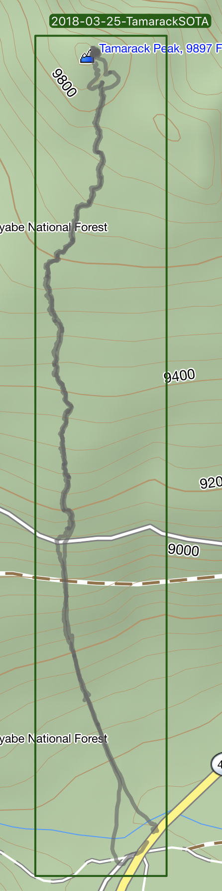 So all that aside it was time to finally push for this peak today. The weather was going to be awesome, the avalanche danger was low for the aspects I was ascending, all I had to deal with was snowshoeing up the fresh powder from the previous week. Fresh untouched powder being the main caveat. The GPS says it’s only one mile from the parking area to the summit, however I logged two miles each way. It took three hours to cover the two miles. The first 1/2 mile was pretty easy thanks to the snowmobiles packing down the snow. Above the forest service road, it was fresh tracks the rest of the way. Even with floaty snowshoes I was sinking up to my calves. Definitely glad I do TRX mountain climbers and buzzsaws. Three hours up, but 45 minutes down. The climb from where I started is approximately 1300 feet.